


Zoning Map &
Land Use Map
Updated November 20, 2020
JUMP TO: GIS | Zoning Map | Land Use Map
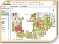
Cerritos GIS Mapping Tool
Cerritos GIS is an interactive, online mapping tool that offers 24-hour access to information regarding properties in Cerritos including zoning, aerial imagery, City data layers, Assessor property data, and entitlement history. This web application offers various tools, including a measure tool that can calculate perimeter, area and distance; a print tool that offers multiple printing options for maps and property reports; and more. Cerritos GIS provides public access to filtered, non-sensitive information.
Zoning Map
The Cerritos Zoning Map, also referred to as the Cerritos Development Map, illustrates the location of land use zones in the City of Cerritos in which identified uses are permitted and prohibited.
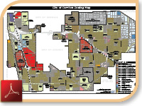
Reference the Cerritos Municipal Code, for specific land use and development requirements for each zone.
ĀĀLand Use Map
The Cerritos Land Use Map is a graphic representation of the goals and policies guiding future development under the Cerritos General Plan. Unlike the Cerritos Zoning Map, which illustrates where uses are currently permitted or prohibited under the Cerritos Municipal Code, the Cerritos Land Use Map illustrates a future development scenario and serves to guide decisions concerning future development.
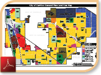
Reference the Cerritos General Plan for goals and policies relating to land use in Cerritos.


